Nova Scotia Power Receives Esri Special Achievement in GIS Award

August 12, 2026
Atlantic Canadian utility recognized for using geographic information systems to support grid resilience, operational continuity and modernization
- Nova Scotia Power has received an Esri Special Achievement in GIS Award for demonstrating leadership in using GIS to support operational resilience and grid modernization.
- Following a significant cyber incident, Nova Scotia Power rapidly shifted key GIS workflows to cloud-based ArcGIS Online.
- The utility is advancing its migration to the ArcGIS Utility Network with Schneider Electric’s Designer XI, setting an example for Canadian utilities modernizing ageing infrastructure and preparing for a more resilient energy future.
Esri Canada congratulates Nova Scotia Power on receiving the Esri Special Achievement in GIS (SAG) Award for its innovative use of geographic information system (GIS) technology to support grid resilience, operational continuity and digital transformation. Presented annually at the Esri User Conference, the SAG Awards celebrate organizations around the world that are using GIS to solve complex problems and deliver measurable impact. Nova Scotia Power was recognized for its grid modernization project that demonstrates how GIS can help utilities adapt quickly, keep essential services running and strengthen the foundation for future grid modernization.
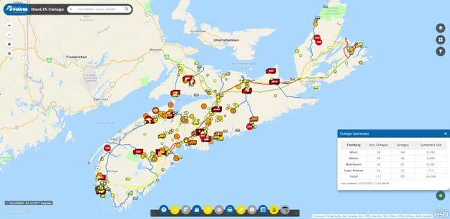
“We are honoured to receive this global recognition from Esri,” said Glen MacLeod, director, Customer & Grid Intelligence, Nova Scotia Power. “Our teams rely on GIS every day to better understand and manage our network, support safe and efficient field operations, and deliver reliable service to our customers. This recognition reflects the dedication of our employees and our ongoing commitment to using innovative technology and data-driven insights to strengthen the grid and enhance the customer experience.”
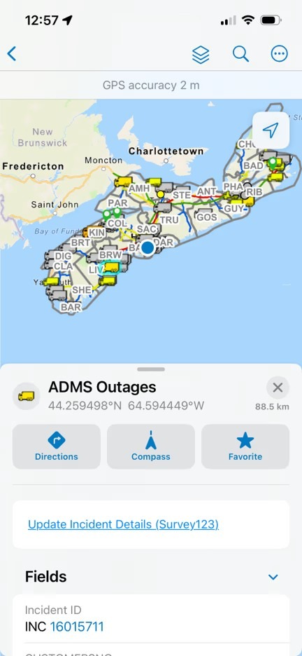
In 2024, Nova Scotia Power began migrating to the ArcGIS Utility Network and upgrading to Schneider Electric’s Designer XI to modernize management of its electrical network with advanced data modelling, visualization and analytics capabilities. When a significant cyber incident disrupted its systems, the organization rapidly transitioned critical workflows to the cloud-based service ArcGIS Online, helping keep more than half of its GIS applications available and supporting essential functions such as meter reading and outage management.
“Nova Scotia Power’s response shows how GIS helps utilities remain resilient when conditions change quickly,” said Alex Miller, president, Esri Canada. “By moving critical workflows to the cloud and continuing its migration, the organization is demonstrating the kind of practical, forward-looking innovation Canadian utilities need as they modernize the grid and prepare for a more complex energy future.”
For Canadian utilities, Nova Scotia Power’s achievement underscores the growing importance of enterprise GIS as critical infrastructure. Utilities across the country are facing increasing pressure to modernize ageing assets, improve outage response, strengthen cybersecurity resilience, manage vegetation and field work more efficiently, and integrate new demands from electrification and distributed energy resources. GIS provides a common operational view that connects network data, field activity, customer impacts and asset intelligence so utilities can make faster, better informed decisions.
Nova Scotia Power has used Esri tools including ArcGIS Field Maps, ArcGIS Experience Builder and ArcGIS Survey123 to support design work, field operations and customer service activities. The organization also shares lessons learned with peers, helping advance best practices in utility management across the Atlantic region.
“The utility sector is facing major change, and GIS is becoming essential to how organizations plan, design, operate and respond,” said Armando LaCivita, director, Utilities, Esri Canada. “Nova Scotia Power’s work is a strong example of how utilities can use the ArcGIS platform to improve data quality, streamline workflows and build a more connected view of their network from the office to the field.”